
Keyword
Earth Science | Biological Classification | Animals/Invertebrates | Arthropods | Crustaceans
174 record(s)
Type of resources
Topics
Keywords
Contact for the resource
Provided by
Formats
Update frequencies
Status
draft
-
Beam trawl surveys of juvenile prawns were carried out between the Vanderlin Islands and Rosy Creek, Gulf of Carpentaria to investigate the impact of dredging by MacArthur River Mines.
-
This dataset contains results from a series of laboratory and field experiments on local grazer communities to determine the parameter values required by the COASEC (Coastal Ocean Ecology) model. These experiments are part of the second stage of the Perth Coastal Waters Study. These parameters were delta, the grazing demand (biomass of food eatern per biomass of grazer per day; beta, the assimilation constant (the difference between the food consumed and defecated as a percentage of the food consumed); micron, the mortality constant (the turnover rate of the community), and kg, the ratio of food available to food demand to satisfy 50% of maximum potential growth of grazer communities. Empirically derived parameter values for the main grazers, crustaceans and gastropods were very different from each other and from the default values in the model. Experiments indicated that both types of grazers primarily fed on periphyton and grazing rates varied between summer and winter. Grazing impacts on larger epiphytes are dependent upon the type of grazer and the species of epiphyte.
-
Field experiments were carried out investigating prawn predation using tethering techniques at three sites in the Embley River in October 1994, December 1994 and April 1995.
-
Surveys of of post-larval and juvenile animals, mainly fish, prawn and other crustaceans, were carried out in 1993 and 1994. Samples were collected using artificial settlement units in the Embley River estuary, Gulf of Carpentaria.
-
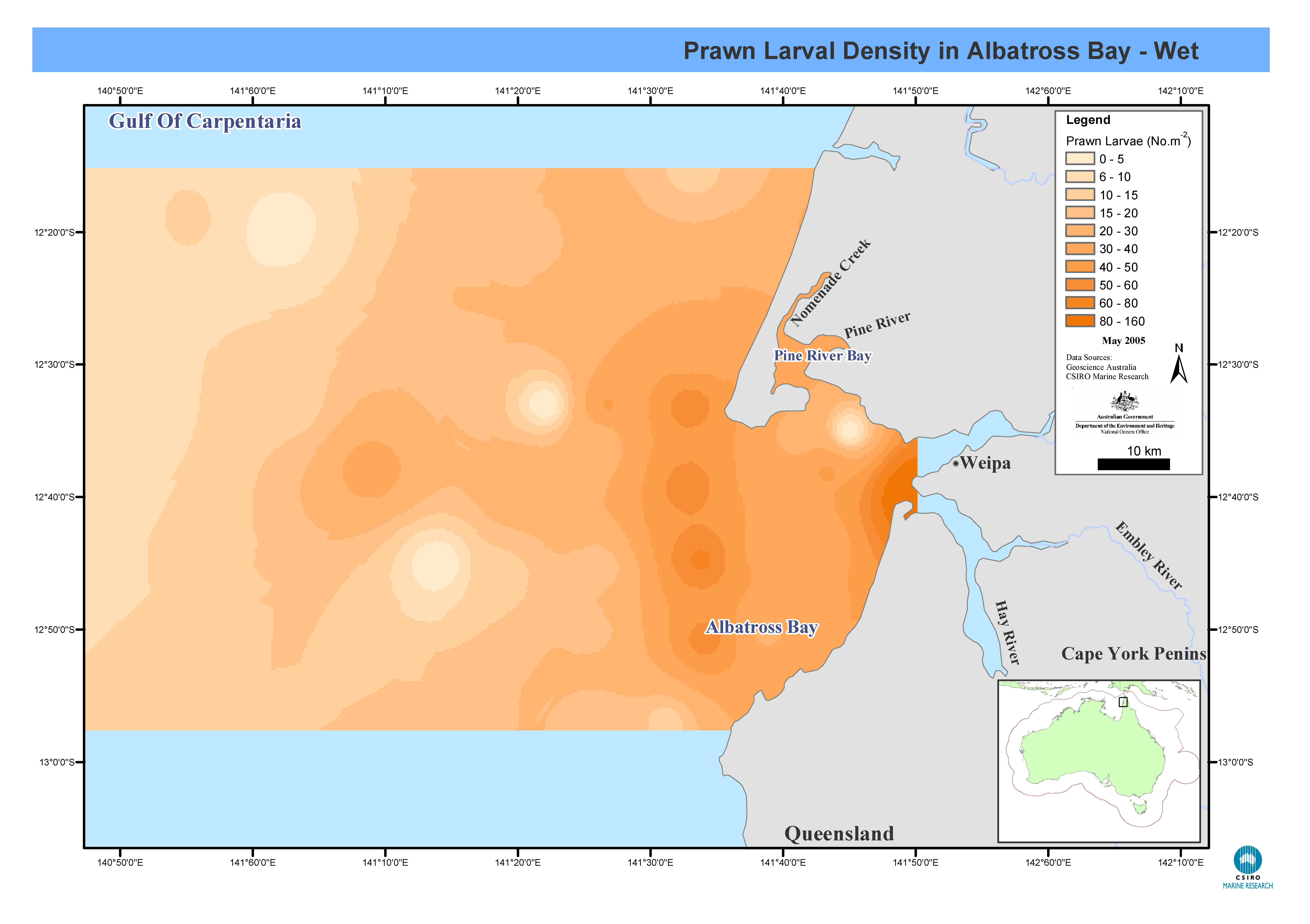
Maps showing prawn larval distribution in Albatross Bay, Gulf of Carpentaria, northern Australia for both the wet and dry seasons. Prawn larval density was recorded from stepped oblique bottom to surface plankton tows in Albatross Bay. Monthly cruises were carried out between March 1986 and April 1992, at twenty-one stations in Albatross Bay, Gulf of Carpentaria. Prawn larval densities were measured and salinity-temperature profiles taken. These maps have been produced by CSIRO for the National Oceans Office, as part of an ongoing commitment to natural resource planning and management through the 'National Marine Bioregionalisation' project.
-
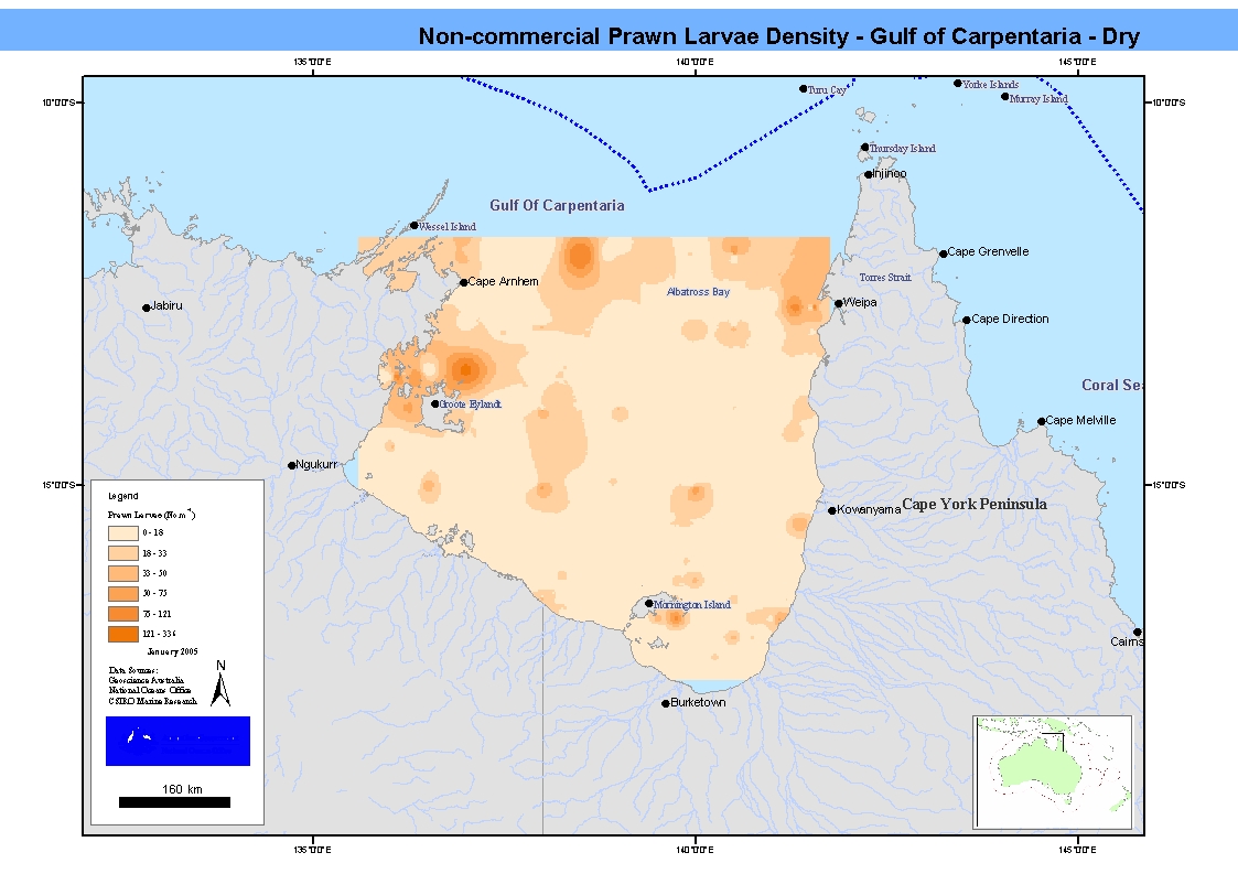
Maps showing prawn larval distribution of non-commercial prawn species during both the wet and dry seasons in Albatross Bay. The data was recorded from stepped oblique bottom to surface plankton tows, 140-142um nets. Nine cruises took place between 1975 and 1977 on chartered boats and the "Kalinda". Prawn larval biomass and densities were measured in several transects across the Gulf of Carpentaria, as well as total plankton biomass. These maps have been produced by CSIRO for the National Oceans Office, as part of an ongoing commitment to natural resource planning and management through the 'National Marine Bioregionalisation' project.
-
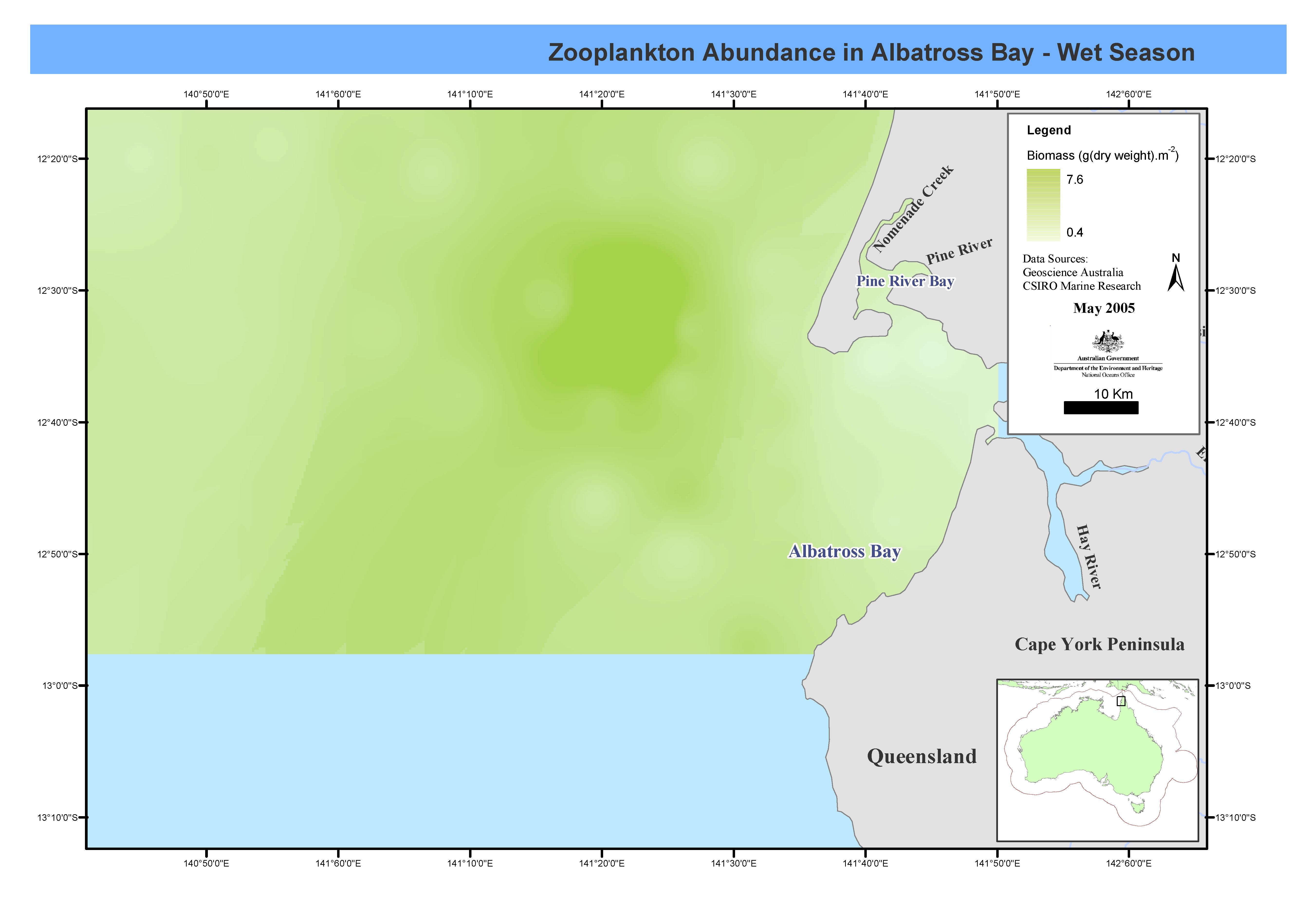
These maps show zooplankton biomass in Albatross Bay for both wet and dry seasons. Monthly cruises were carried out between March 1986 and April 1992, at twenty-one stations in Albatross Bay, Gulf of Carpentaria. Prawn larval densities were measured and salinity-temperature profiles taken. Theses maps have been produced by CSIRO for the National Oceans Office, as part of an ongoing commitment to natural resource planning and management through the 'National Marine Bioregionalisation' project.
-
Data showing total zooplankton biomass (dry weight) from stepped oblique bottom to surface plankton tows for both the wet season and dry season in Albatross Bay. Biomass estimates from two mesh sizes. Nine cruises took place between 1975 and 1977 on chartered boats and the "Kalinda". Prawn larval biomass, prawn larval densities and total zooplankton were measured in several transects across the Gulf of Carpentaria.
-
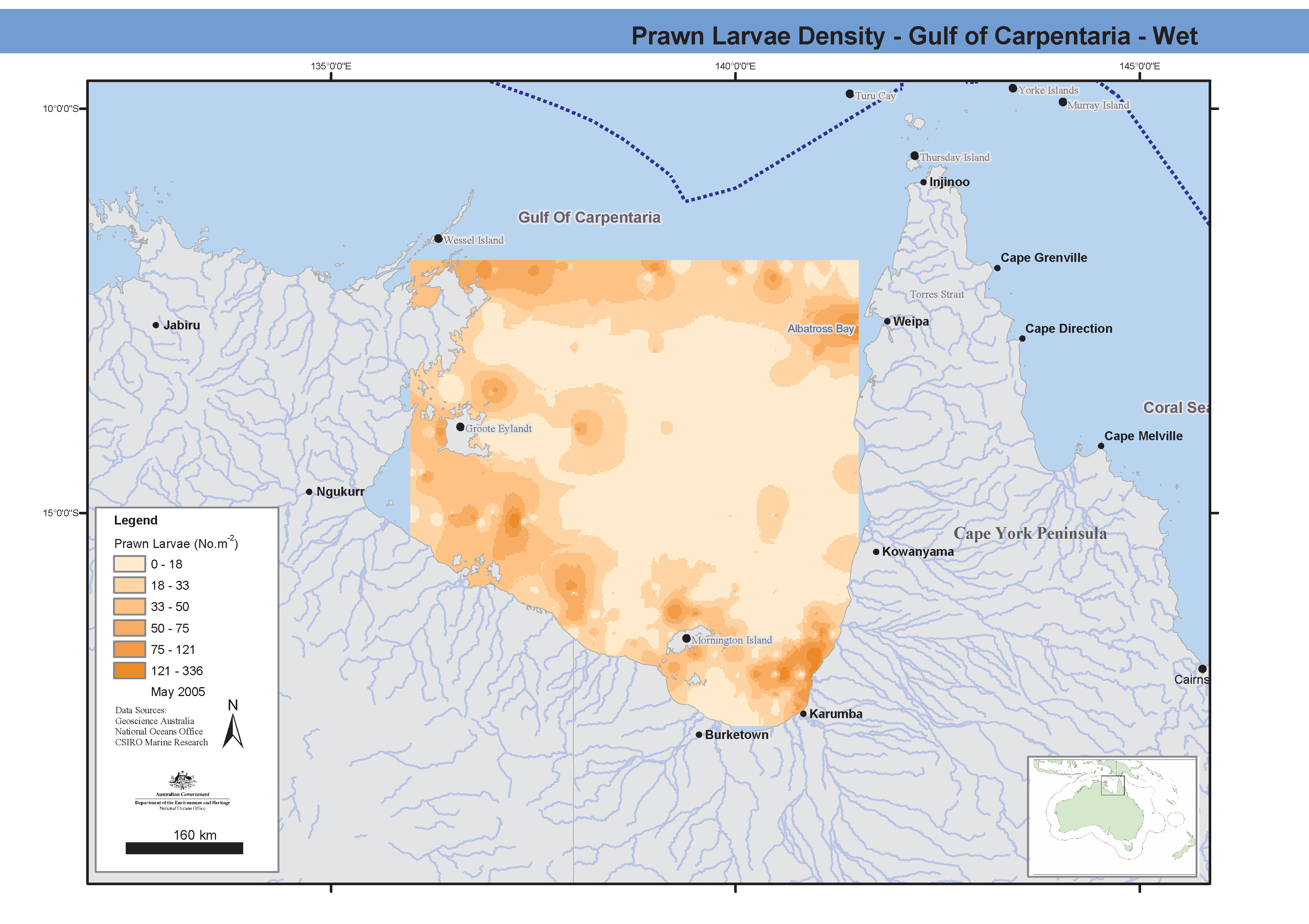
Maps showing prawn larval distribution of commercial and non-commercial species during both the wet and dry seasons in Albatross Bay. The data was recorded from stepped oblique bottom to surface plankton tows, 140-142um nets. Nine cruises took place between 1975 and 1977 on chartered boats and the "Kalinda". Prawn larval biomass and densities were measured in several transects across the Gulf of Carpentaria, as well as total plankton biomass. These maps have been produced by CSIRO for the National Oceans Office, as part of an ongoing commitment to natural resource planning and management through the 'National Marine Bioregionalisation' project.
-
Between March 1986 and April 1992, monthly cruises were carried out at twenty-one stations in Albatross Bay, Gulf of Carpentaria. Prawn larval densities were measured and salinity-temperature profiles taken. Prawn larval density from stepped oblique bottom to surface plankton tows. Net sizes were 142 or 140m mesh, 250micron mesh with a 0.5x0.5 square frame, stepped-oblique tow. In this dataset Penaid prawn counts were recorded to species level for the genus Penaeus only, for larval stages Mysis 1-3. (Identification was not possible for other larval stages).